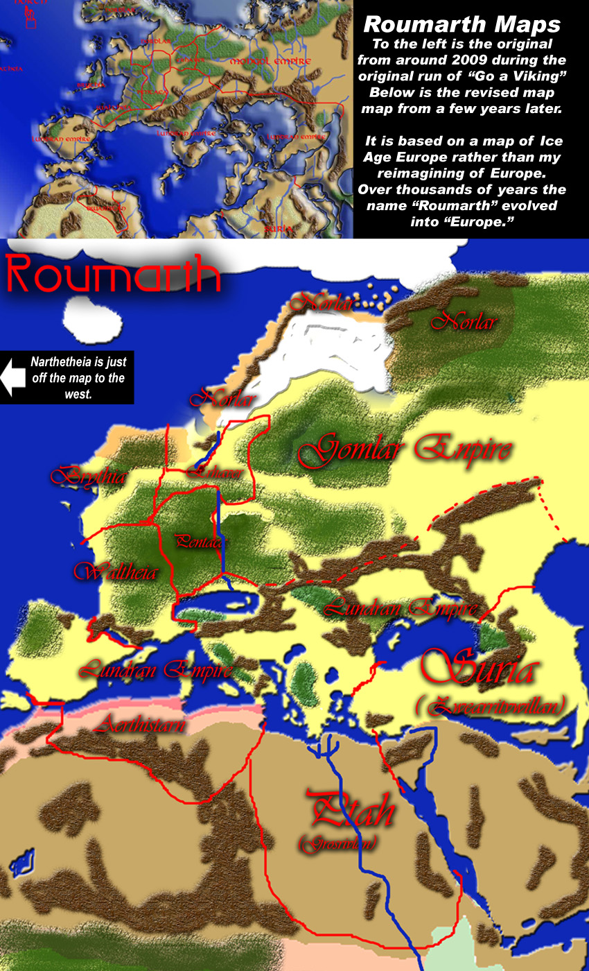
Narthatheia is a group of islands a little larger than Iceland. There has to be more– So I made a continent based on Europe. It was always intended that this world was our own from the very dawn of man around 35,000 years ago. Robert E. Howard would put Conan somewhat later after the fall of Atlantis.
Here, Aztlan is going strong but lies a treacherous two month voyage to the west. So Narthatheians mostly look east to Roumarth. The original shapes never quite seemed right so I found some Pleistocene maps of Europe and followed them. This is during one of the warm periods during the Ice Age where the ice receded a little in this hemisphere. The western hemisphere has far more extensive glaciation.
So this provides a Britain (Brythia) attached to mainland Europe (Roumarth) and with the Mediterranean an enclosed inland sea. The northern coasts of the Middle Sea are ruled by the fading Lundran Empire (created by a friend and used with his permission). Waltheia and Pentca on the western shore of the continent broke off the Lundran empire when it came under fierce attack by the armies of the Gomlar about a century ago. (There was a D Great Riverland and Land of Two Rivers. Aerthistarn is a great dwarven empire that broke off the Lundran empire in ages past.
The Egyptian gods rule Ptah and the Sumerian gods rule Suria. There is trade and travel through Lundran intermediaries. Much is the same about the lands off the map to the south and those that lie to the west. If anything the only lands with most contact are those to the far east, the fabled nine kingdoms of Sinesia. The Gomlar maintain direct links to them and employ many Sinesians in their empire.
Clothing, culture and style might have changed over time but most of how people actually lived really didn't change much until the use of steam power. The idea of civilizations rising and falling over and over makes sense. Thinking of Colonel Taylor pointed out at the end of the original POTA movie looking around in the cave....Wonder what some future archaeologist might think of my miniature Space Battleship Yamato. Or my Robby the Robot? Or the massive porn collection.... Will a future historian think the statue of Rocky in Philly is of a real person?
There are several examples of toys presaging unexplored avenues of technology. The ancient Egyptians had bird like toy gliders, the Native americans had wheeled toy animals. Renaissance children had toy string launched propellers. Archimedes had a toy steam engine. A child's toy or a cult ritual item worshipping Robby Robot. 😉
Echoing Cid, always found the idea of a sort of 'lost history' of earth fascinating. Of course, if there was any, I doubt they'd have as 'medieval' a feel as Tolkein's and Howard's reimaginings, but then... maybe History really does repeat itself. Narthatheia... An island civilization off to the left... will a cataclysm send it to the bottom of the sea eventually?! :D
Tolkien was solidly Anglo-Saxon and Norse. Howard borrowed from Theosophy as did Lovecraft. There are many cultures through history that resembled Medieval Europe in many of its trappings from China to Africa to Anatolia to the Americas. More feathers, no steel or monotheism but still a rigid feudal hierarchy. And most also had chain mail and mounted warriors. Humans have an annoying tendency to build the same systems again and again.
I've always been a fan of the idea of using prehistoric Earth as a setting for fantasy tales, the way Howard did with Conan. And what's this? Sea levels actually rose dramatically thousands of years ago? Thank goodness this is only a work of fantasy!


AmeliaP at 3:33PM, Oct. 16, 2018
Okay, if you compile your text, your art and your story, you can create and sell a RPG scenario with all this info o__O. It's impressive!
KDog at 7:52AM, Sept. 30, 2018
So where is Indiana Jones flying today?
bravo1102 at 3:04PM, Sept. 30, 2018
He's in that white arrow going off to the left.
Jason Moon at 9:11PM, Sept. 27, 2018
It's like Terraria, better watch out for the spreading of crimson or hallow
bravo1102 at 12:55AM, Sept. 28, 2018
It'll never get that far.
plymayer at 1:07AM, Sept. 27, 2018
Clothing, culture and style might have changed over time but most of how people actually lived really didn't change much until the use of steam power. The idea of civilizations rising and falling over and over makes sense. Thinking of Colonel Taylor pointed out at the end of the original POTA movie looking around in the cave....Wonder what some future archaeologist might think of my miniature Space Battleship Yamato. Or my Robby the Robot? Or the massive porn collection.... Will a future historian think the statue of Rocky in Philly is of a real person?
bravo1102 at 1:27AM, Sept. 27, 2018
There are several examples of toys presaging unexplored avenues of technology. The ancient Egyptians had bird like toy gliders, the Native americans had wheeled toy animals. Renaissance children had toy string launched propellers. Archimedes had a toy steam engine. A child's toy or a cult ritual item worshipping Robby Robot. 😉
bravo1102 at 1:18AM, Sept. 27, 2018
It's a statue of the boxing God Balboa who also invented the Pacific Ocean.
plymayer at 12:58AM, Sept. 27, 2018
Fascinating.
KimLuster at 10:01AM, Sept. 26, 2018
Echoing Cid, always found the idea of a sort of 'lost history' of earth fascinating. Of course, if there was any, I doubt they'd have as 'medieval' a feel as Tolkein's and Howard's reimaginings, but then... maybe History really does repeat itself. Narthatheia... An island civilization off to the left... will a cataclysm send it to the bottom of the sea eventually?! :D
bravo1102 at 12:53PM, Sept. 26, 2018
Tolkien was solidly Anglo-Saxon and Norse. Howard borrowed from Theosophy as did Lovecraft. There are many cultures through history that resembled Medieval Europe in many of its trappings from China to Africa to Anatolia to the Americas. More feathers, no steel or monotheism but still a rigid feudal hierarchy. And most also had chain mail and mounted warriors. Humans have an annoying tendency to build the same systems again and again.
jerrie at 9:29AM, Sept. 26, 2018
I hereby crown you KING of Drunk Duck comics world building!
bravo1102 at 12:55PM, Sept. 26, 2018
I am a dwarf perched on the shoulders of giants.
El Cid at 8:35AM, Sept. 26, 2018
I've always been a fan of the idea of using prehistoric Earth as a setting for fantasy tales, the way Howard did with Conan. And what's this? Sea levels actually rose dramatically thousands of years ago? Thank goodness this is only a work of fantasy!
bravo1102 at 8:47AM, Sept. 26, 2018
Researchers like Graham Hancock and Charles Hapgood have gone on about in book after book for decades.