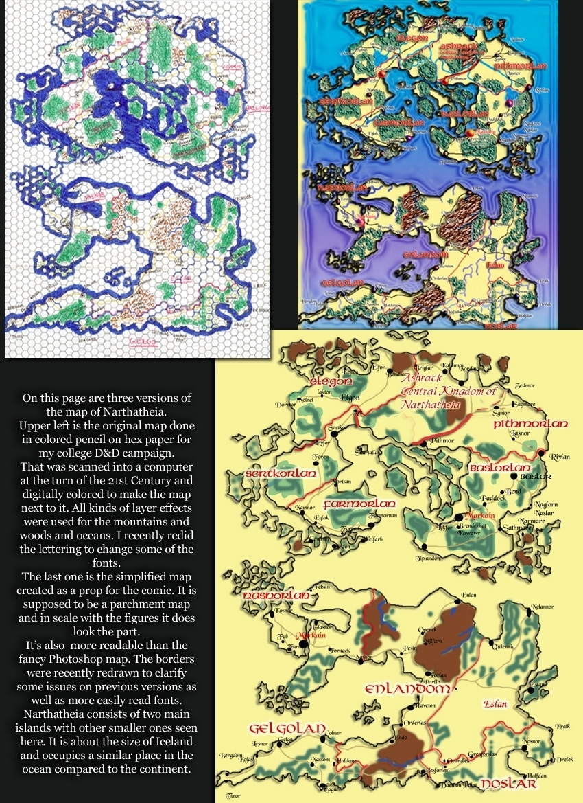
You are inventing a new world, with new places so there should be some kind of guide for how to get around. Geography shapes us all so how is it shaped in your world? And if you draw a map really like it once upon a time the transition between drawn and digital wasn't that easy if you did full size artwork. The first map of Narthatheia that really worked was a 36“ x 60” wargame map. There was no way to scan that. So I drew the hex map seen here. The hexes were 1/4“ as opposed to 3/4” so the map was that much smaller and much easier to carry around and small enough to fit on a scanner.
Hey, why are there two Markains? In the days of the old high kings both islands had a capital city that was the seat of high king when in residence. Markain was that city. They used to have designations of North and South but as the politics on the islands drifted apart each island tried to claim they had THE Markain.
Why are the names and borders different on the hex map and the other two? Two different historical eras. The Photoshop maps are for the comic during the time of Falkimir. The hex map is a few hundred years later representing the some changes Falkimir would make to the map.
Nice map. It looks like somebody took England and the Mediterranean and put them in a blender together! You can immediately see the potential for military campaigns and fighting over trade routes.
That is some pretty impressive map-making!! I've PnP RP'd in the past, but I never had the skill (nor patience) to do something like this!! Excellent!!


El Cid at 11:52AM, July 17, 2017
Nice map. It looks like somebody took England and the Mediterranean and put them in a blender together! You can immediately see the potential for military campaigns and fighting over trade routes.
bravo1102 at 5:28PM, July 17, 2017
Now you know why they were in such a hurry to crown Falkimir. A strong leader like him has been needed for over two generations.
KimLuster at 6:19AM, July 17, 2017
That is some pretty impressive map-making!! I've PnP RP'd in the past, but I never had the skill (nor patience) to do something like this!! Excellent!!
bravo1102 at 6:49AM, July 17, 2017
Had to, as the world got bigger I had to know where everything was and how long it took to get from place to place.
Banes at 5:45AM, July 17, 2017
That's really cool - nice to see these in more detail.
bravo1102 at 2:01AM, July 18, 2017
Spent a whole night updating and refining the map. I forgot all the water! Should be up soon.
bravo1102 at 6:47AM, July 17, 2017
That is coming soon.
Jason Moon at 1:42AM, July 17, 2017
Those are very detailed. Id like to get my hands on the colored pencil map
bravo1102 at 4:40AM, July 17, 2017
The thing about making scans is I can always find the scan file but I can never find the original.
jerrie at 1:25AM, July 17, 2017
cool stuff
plymayer at 1:03AM, July 17, 2017
OOoooo! Love maps. Always have.
bravo1102 at 4:39AM, July 17, 2017
So do I. Even taught map reading in the Army.